


Voting District 0372214000005, Clinton County, Michigan
About
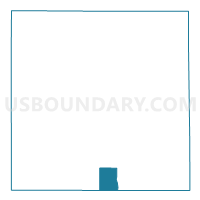
Outline

Summary
| Unique Area Identifier | 596289 |
| Name | Voting District 0372214000005 |
| County | Clinton County |
| State | Michigan |
| Area (square miles) | 7.00 |
| Land Area (square miles) | 6.97 |
| Water Area (square miles) | 0.03 |
| % of Land Area | 99.60 |
| % of Water Area | 0.40 |
| Latitude of the Internal Point | 42.79174530 |
| Longtitude of the Internal Point | -84.58500670 |
Maps

Graphs
Select a template below for downloading or customizing gragh for Voting District 0372214000005, Clinton County, Michigan


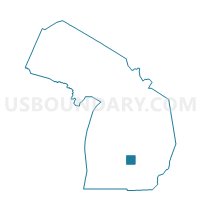
Neighbors
Neighoring Voting District (by Name) Neighboring Voting District on the Map
- Voting District 0372214000002, Clinton County, MI
- Voting District 0372214000003, Clinton County, MI
- Voting District 0372214000004, Clinton County, MI
- Voting District 0372214000006, Clinton County, MI
- Voting District 0372214000007, Clinton County, MI
- Voting District 0378440000002, Clinton County, MI
- Voting District 0452152000041, Eaton County, MI
- Voting District 0654600001001, Ingham County, MI
- Voting District 0654600004013, Ingham County, MI
- Voting District 0654600004014, Ingham County, MI
Top 10 Neighboring County Subdivision (by Population) Neighboring County Subdivision on the Map
- Lansing city, Ingham County, MI (109,563)
- Delta charter township, Eaton County, MI (32,408)
- DeWitt charter township, Clinton County, MI (14,321)
- Watertown charter township, Clinton County, MI (4,836)
Top 10 Neighboring Place (by Population) Neighboring Place on the Map
Top 10 Neighboring Unified School District (by Population) Neighboring Unified School District on the Map
- Lansing Public School District, MI (122,593)
- Waverly Community Schools, MI (20,625)
- DeWitt Public Schools, MI (13,798)
Top 10 Neighboring State Legislative District Lower Chamber (by Population) Neighboring State Legislative District Lower Chamber on the Map
- State House District 93, MI (98,165)
- State House District 71, MI (97,665)
- State House District 68, MI (89,568)
Top 10 Neighboring State Legislative District Upper Chamber (by Population) Neighboring State Legislative District Upper Chamber on the Map
- State Senate District 24, MI (278,340)
- State Senate District 33, MI (272,940)
- State Senate District 23, MI (258,851)
Top 10 Neighboring 111th Congressional District (by Population) Neighboring 111th Congressional District on the Map
Top 10 Neighboring Census Tract (by Population) Neighboring Census Tract on the Map
- Census Tract 103, Clinton County, MI (4,836)
- Census Tract 101.08, Clinton County, MI (4,070)
- Census Tract 101.07, Clinton County, MI (3,568)
- Census Tract 33.01, Ingham County, MI (3,074)
- Census Tract 201.01, Eaton County, MI (2,829)
- Census Tract 32, Ingham County, MI (2,245)
- Census Tract 102.01, Clinton County, MI (2,100)
- Census Tract 102.04, Clinton County, MI (1,907)
- Census Tract 102.03, Clinton County, MI (1,627)